First, let’s get the name out of the way. Once we had bought part of the land attached to Bunt’s Hill Farm, we knew we would have to find a separate name to identify the new holding.
The Bunt’s Hill name goes back to Anglo Saxon times some 1,000 years ago. It appears as Mot Beorh in a Land Charter in AD 968 in the reign of King Edgar.
Mot Beorh means moot or mound implying the high land where today’s farm sits was an assembly hill. Whilst our land downhill from the Mot Beorh was not named separately, traditionally at the time it would be beorh botm (or bytme) meaning land below or at the foundation.
From these origins many IoW and UK names have evolved, for example – e.g. Lynnbottom, Fern Bottom, and Bunker’s Bottom.
Site Description
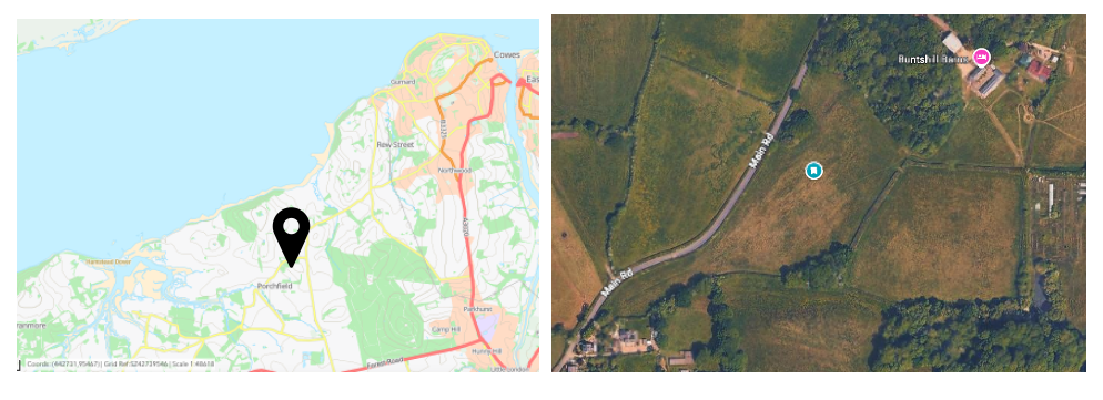
Bunt’s Hill lies on the North Western side of the Isle of Wight Biosphere reserve, just a short walk North of the village of Porchfield. The farm sits off a country road officially called Main Road but variously called Corfe Hill or Bunt’s Hill locally. The farm buildings sit at the top of the hill and are now residential barns (Bunt’s Hill Barns). Since the death of the farmer Ken Shynn in 2021, the farmland has been up for sale and the fields used just for hay.
Initially we were looking a the possibility of buying two fields, the western one being called the ‘Road Field’ as its longest side abuts Main Road. The eastern field we will call “Five Acre Field” as there is evidence that it has been called that for at least 80 years.
The site is of strategic ecological importance as it sits within the Isle of Wight Biosphere Reserve and just across the road from the IoW National Landscape and Heritage Coast. Surrounded by several ancient woodland patches, it’s a hotspot for connectivity and ecological flow. As such, the site was also identified by the Local nature Recovery strategy as a ‘Site that Could become Important for Biodiversity’ (ACB).
Whilst looking around the fields it became clear that there was a large pond in the field to the east of Five Acre Field which also had dilapidated buildings. We later found that this was previously an intensive mink farm and that it had been largely undisturbed since mink farming was banned in 2002. To an ecologist the lure of a pond that has been regenerating ecologically for more than two decades is like catnip. We managed to include the pond in the purchase, so now we have two fields and a mink pond to structure our project around. Actually I should say two ponds. In the Road Field there is a seasonal pond just inside the field entrance from the road. It is also as old as the first maps of the area and provides a wealth of upgrading and research opportunities.
Geologically the whole site rests on Hampstead Beds. Formed around 34 million years ago, they consist of layered sands and clays that are renowned to impervious i.e. water retentive. This is an important factor shaping the hydrology of the area and the use to which the land has been put. A seasonal ditch system runs along the south of Bunt’s Bottom, directing water from east to west and eventually to Newtown Estuary, a site of Special Scientific Interest (SSSI).
Restoration vision
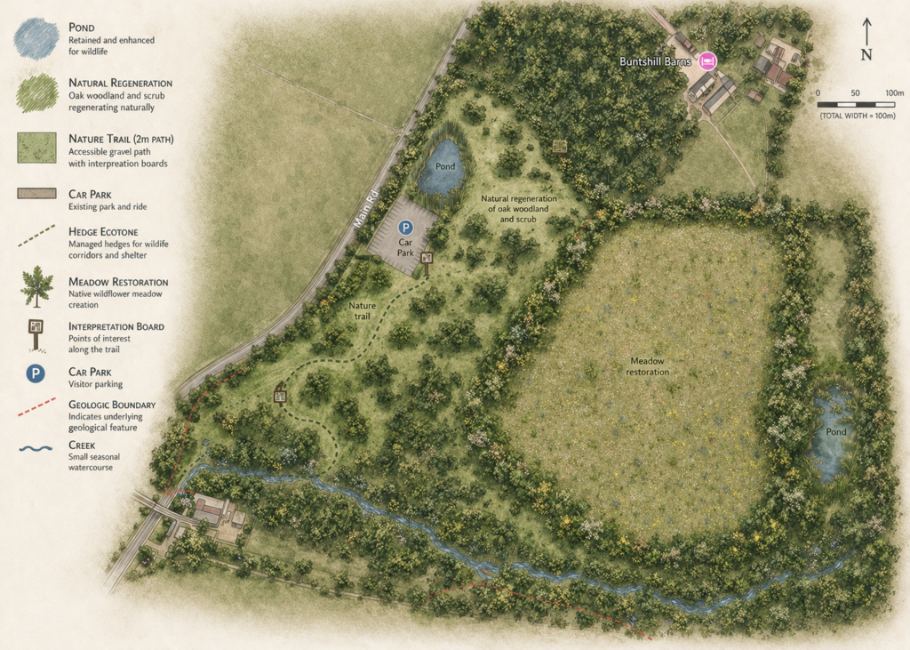
We aim to create a diverse habitat mosaic – helping to reconnect ancient woodland patches, while keeping some open habitats for ground nesting birds and pollinators, and restoring the two ponds and giving the hedges and boundary vegetation space to expand. The Western field ‘Road Field’ Will have a small car park for ease of access, natural regeneration areas, and a restoration trail wiggling through the habitat mosaic and woodland planting, and connecting to the existing footpath network. The Eastern field ‘Five Acre Field’ will be restored towards a biodiverse lowland meadow, with a mix of flowering plants and grasses and with soft hedges and edges. The large Eastern pond will be turned into a bird and wildlife heaven with restoration of riparian and aquatic vegetation.